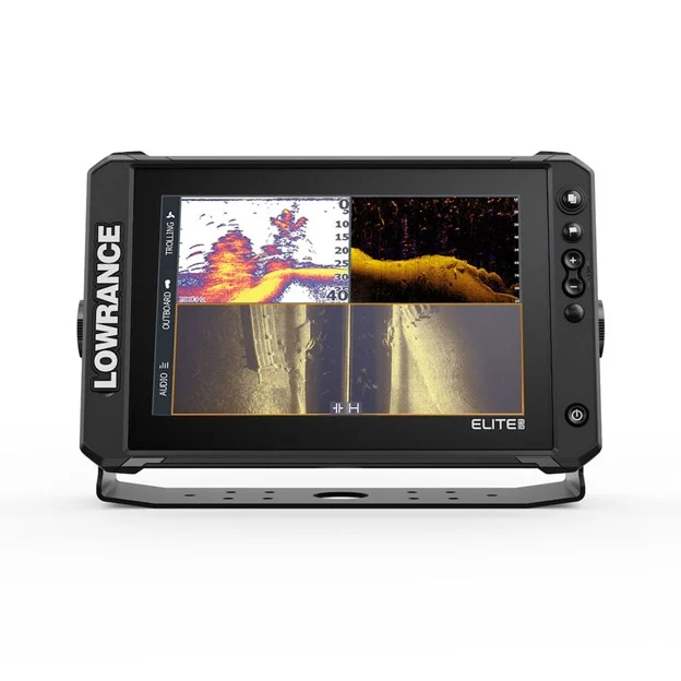
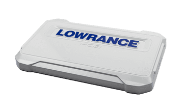
Display
Displayresolutie 1280x800
Kijkhoeken 85° top/bottom85° left/right
Kleur achtergrondverlichting Pure White LED
Schermgrootte 10 inches
Schermhelderheid >1200 nits
Connectiviteit
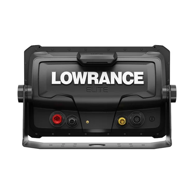
Aan te sluiten op NMEA 2000 1x Micro-C
Aan te sluiten op pc None
Bluetooth Integrated Bluetooth 4.0 with support for Bluetooth Classic
Ethernetpoorten 1 x 100Mbit
Gegevensopslag SD-kaart 1 micro SD card up to 32GB
item beschikt over Wi Fi verbinding Internal 802.11b/g/n
N2K-PGN's Receive only65240 ISO Commanded Address, 127245 Rudder, 127251 Rate of Turn, 127257 Attitude, 127488 Engine Parameters, Rapid Update, 127489 Engine Parameters, Dynamic, 127493 Transmission Parameters, Dynamic, 127505 Fluid Level, 127508 Battery Status, 129033 Time and Date, 129038 AIS Class A Position Report, 129039 AIS Class B Position Report, 129040 AIS Class B Extended Position Report, 129794 AIS Class A Static and Voyage Related Data, 129801 AIS Address Safety Related Message, 129802 AIS Safety Related Broadcast Message, 129808 DSC Call Information, 130313 Humidity, 130314 Actual Pressure, 130576 Small Craft Status, 65285 Temperature with Instance, 65325 Reprogramming Status, 65480 Parameter Reply, 130817 Product Information, 130820 Reprogramming Status, 130832 Fuel Used – High Resolution, 130834 Engine and Tank Configuration, 130838 Fluid Level Warning, 130842 AIS and VHF Message Transport, 130843 Sonar Status – Frequency and DSP VoltageTransmit and Receive:59392 ISO Acknowledgement, 59904 ISO Request, 60160 ISO Transport Protocol, Data Transfer, 60416 ISO Transport Protocol, Connection Management, 60928 ISO Address Claim, 126208 NMEA Group Function, 126464 Receive/Transmit PGN’s group function, 126992 System Time, 126996 Product Information, 127237 Heading/Track Control, 127250 Vessel Heading, 127258 Magnetic Variation, 128259 Speed, 128267 Water Depth, 128275 Distance Log, 129025 Position, Rapid Update, 120296 COG and SOG, Rapid Update, 129029 GNSS Position Data, 129283 Cross Track Error, 129284 Navigation Data, 129539 GNSS DOPs, 129540 GNSS Sats In View, 130074 Route and WP Service – WP List - WP Name and Position, 130310 Environmental Parameters, 130311 Environmental Parameters, 130312 Temperature, 130577 Direction Data, 61184 Parameter Command, 65292 Clear Fluid Level Warnings, 65293 LGC-2000 Configuration, 65323 Data User Group Request, 130831 EP-20 Suzuki Engine and EP-50 Storage Device Configuration, 130835 Set Engine and Tank Configuration, 130839 EP-45 Pressure Configuration, 130840 Data User Group Configuration, 130845 Parameter Handle, 130850 Event Command, 130851 Event ReplyTransmit only65287 Temperature Sensor Configuration, 65289 Trim Tab Configuration, 65290 Paddle Wheel Speed Configuration, 130818 Reprogramming Data, 130819 Request Reprogram, 130828 Set Serial Number, 130836 Fluid Level Configuration, 130837 Fuel Flow Turbine Configuration
Ondersteuning voor NMEA 0183-sentences None
Video None
Cartografie
Ondersteunde kaarten C-MAP (MAX N, MAX N+), C-MAP Genesis, C-MAP Precision Contour HD (AMER ONLY), Navionics (Gold, NAV+ Platinum+), Insight (Pro and HD), Lowrance Regional Mapping Partners
Elektrisch
Aanbevolen stroomsterkte zekering 3A
Max. stroomverbruik 2.5A @ 13.8VDC with backlight on full
Min. stroomverbruik 34.5W (2.5A @ 13.8VDC with backlight on full)
Normaal stroomverbruik 2.5A @ 13.8VDC with backlight on full
Voedingsspanning1 2v DC (10.8-17VDC)
Omgeving
Bedrijfstemperatuurbereik 5°F to 131°F (-15°C to 55°C )
Opslagtemperatuurbereik 4°F to 140°F (-20°C to 60°C )
Schokabsorptie 100,000 cycles of 20 G
Vochtigheid 60°C, 95% relative humidity (RH) for 18 hours
Waterbestendigheid IPX7 with card door closed
GPS
Correctie DGPSWAASMSASEGNOSGLONASS
GPS-ontvangstkanalen 16
Positienauwkeurigheid 20m RMS
Tijd tot eerste positiebepaling 30s
Updatesnelheid 10 Hz
MFD
AIS AIS Chart overlay. Target vessel details.
Digital switching None
Geschikt voor sonar Integrated: CHIRP BroadbandActive Imaging DownScan, Active Imaging SideScan, ActiveImageing HD with an S3100Compatible with:S3100SonarHubStructureScanStructurreScan 3DLiveSightActive Target
GPS 10 Hz Internal high-sensitivity WAAS + EGNOS + MSAS
Inclusief cartografie C-MAP Contour + (US models)Navionics basemap (AMER, AUS/NZ and ROW models)
Interne opslag None
Multimedia SonicHubSonicHub2FusionLink productsany NMEA 2000 compliant Marine Aduio products
Stuurautomaat Outboard PilotGhost Trolling MotorRecon Trolling motor (software dependent)MotorGuide Xi5/Xi3 Trolling Motor **requires Motorguide PinPoint Gateway
Waypoints, routes, tracks 3000 Waypoints100 Routes100 Trails with up to 10,000 points per trail
Weer SiriusXM via WM-4 (USA only)
Fysiek
Gewicht 3.66 lbs (1.66 kg)
Kompasbescherming 2.1 ft (0.65 m)
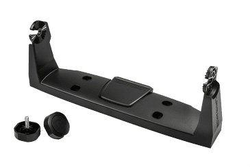
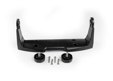
Type montage Gimbal Bracket or Dash Flush Mount
Ander
Garantieperiode 2 Year
InterfaceMulti-Touch TouchscreenZoom +/-MOB = (+/- combined)PagesWaypointLight/Power
TalenStandard Language Pack: Afrikaans/Afrikaans, Danish/Dansk, German/Deutsch, English (US), English (UK), Spanish/Español, Finnish/Suomi, French/Français, Greek/Ελληνικά, Icelandic/íslenska, Italian/Italiano, Dutch/Nederlands, Norwegian/Norsk, Portugese (Brazil)/Português (BR), Portugese (Portugal)/Português (PT), Swedish/SvenskaAsian Language Pack: English (US), English (UK), Japanese/日本語, Korean/한국어, Thai/ภาษาไทย, Chinese - (simplified) China/简体中文, Chinese - (traditional) Taiwan/繁體中文Eastern European Language Pack:Bulgarian/Български, German/Deutsch, Estonian/Eesti, English (US), English (UK), Spanish/Español, French/Français, Hebrew/ عبری , Croatian/ Hrvatski, Hungarian/ Magyar, Italian/Italiano, Lithuanian/Lietuvos, Latvian/ Latvijas, Polish/Polski, Slovak/ Slovensky, Turkish/TürkçeRussia/Ukraine Language pack: German/Deutsch, English (US), English (UK), Spanish/Español, Italian/Italiano, Russian/Русский, Ukraine/ УкраїнськаMiddle Eastern Language Pack: Arabic (UAE)/ العربية , German/Deutsch, English (US), English (UK), Farsi/ فارسی , French/Français, Italian/Italiano